NTU Engineering Students Shine at Engineering Innovation Challenge (EIC) 2019 with Autonomous Radiation-mapping Robot
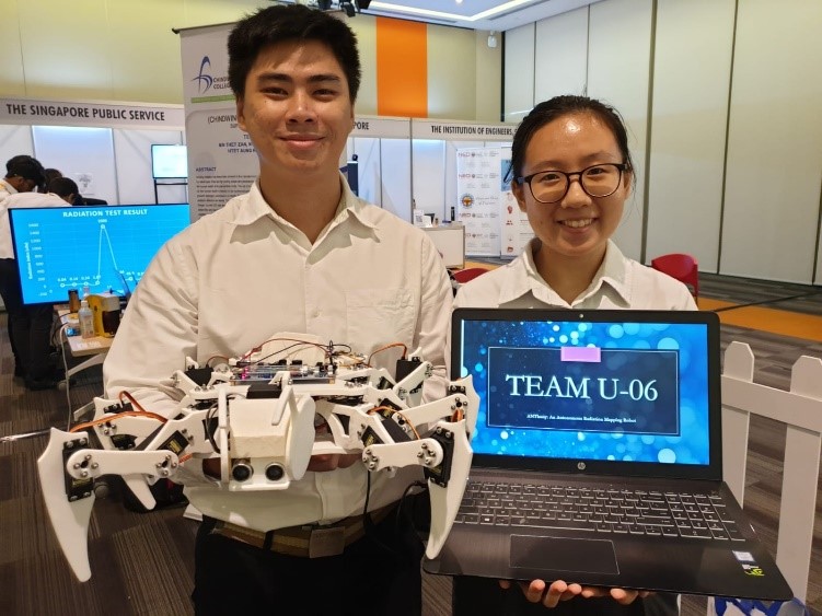
From left: Marcus (MAE) and Ching Yen (SCSE) with their winning robot
MAE would like to congratulate our student Marcus Teo and his classmate for winning the third prize in the university category of the Engineering Innovation Challenge (EIC) 2019, jointly organised by the Institution of Engineers, Singapore (IES) and Science Centre Singapore!
The theme for this year's challenge was "Radiation is Everywhere" and participants were tasked to build radiation detectors and find suitable use cases for their products.
The team from NTU Singapore designed an autonomous radiation-mapping robot called ANThony, to track and log radiation levels autonomously, making the overall process more convenient, user-friendly and safe for its users.
How ANThony works
ANThony is a 6-legged robot fitted with a radiation sensor on top of its body. Inspired by nature, it follows the same principles of locomotion used by insects that allows it to move with a high degree of flexibility in its working environment.
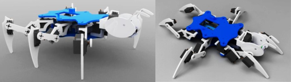
ANThony in walking mode (left) and sliding mode (right)
ANThony is smaller than most existing autonomous robots, yet capable of traversing all kinds of terrains, including rough ground, gaps, inclines, and even steps. It has 2 modes of transport – walking and sliding. In the walking mode, ANThony uses all its legs to navigate through uneven terrains for a more precise position control. In the sliding mode, it goes into a lowered position and rests on its casters located at the bottom of its body. In this position, ANThony will use its legs to propel itself, minimising the use of energy while moving across smooth surfaces. Having two modes of transportation makes ANThony a much efficient, all-terrain autonomous robot since it is able to integrate the benefits of both wheeled and legged locomotion movements.
The team also created an Android app to record the radiation values collected by the robot and present the data and area covered in the form of a map. Every time ANThony makes a move, the map updates ANThony's position and the radiation value at that coordinate with colour ̶ 'green' indicates a normal radiation level and 'red' indicates a high radiation level. In addition, the app allows the user to have an overview of the extensiveness of the radiation level by resizing and repositioning the map on his/her mobile device.
ANThony can also be deployed to contaminated sites that are potentially hazardous to humans. By doing so, the user or response team will be able to identify the areas of radiation and scale of damage from their mobile devices at a safe distance without risking their health and safety.
Content credits: NTU College Of Engineering