


/enri-thumbnails/careeropportunities1f0caf1c-a12d-479c-be7c-3c04e085c617.tmb-mega-menu.jpg?Culture=en&sfvrsn=d7261e3b_1)

/cradle-thumbnails/research-capabilities1516d0ba63aa44f0b4ee77a8c05263b2.tmb-mega-menu.jpg?Culture=en&sfvrsn=1bc94f8_1)

7e6fdc03-9018-4d08-9a98-8a21acbc37ba.tmb-mega-menu.jpg?Culture=en&sfvrsn=7deaf618_1)

How ASE turned overseas field courses into exploration of Singapore during the pandemic

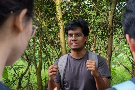
ASE students investigating the geology of St John's and Lazarus Islands. Photo credits: Lee Wei Kit (left) and Raquel (right)
Field courses have been a core part of The Asian School of Environment (ASE) curriculum from the start, many of them overseas in places like Bali, Sri Lanka, Batam Island, and Taiwan. Through the field courses, students get the chance to apply knowledge from the classroom, and gain experience using field methodology and equipment.
When the pandemic struck and travel had been restricted, the initial reaction was to postpone field courses, but as time passes by, ASE course coordinators have come up with a range of local solutions to maintain the field experience for ASE students. The value of students knowing their local environment has become more evident, and some local options are most likely here to stay also after international travel is possible again.
Below are a few examples of how ASE instructors reworked field courses so they could be carried out locally in Singapore.
ES3002 Structural Geology and Tectonics
This course, taught by Asst Prof Judith Hubbard with field course coordinator Brian Perttu, is about how the Earth's crust deforms - the stresses inside the Earth, the strength of the rocks, and the way that they fracture and fold in respond to those stresses. The field trip is intended to give students time to look at these types of deformation features in real life, as well as practice some general "geology skills" - self-location on a map, relating map topography to real topography; rock identification and description; sketching; measurement of orientation; hiking; time management; outdoors experience.
The course has previously gone to Taiwan, observing the deformation and earthquake records from west to east, starting with the 1999 Chi-Chi earthquake in the west and crossing the mountains through progressively older and more heavily deformed rocks, before coming back out into recent earthquake history in the east. This year, instead, the students got to explore the geological outcrops on St. John's and Lazarus Islands in Singapore.
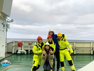
The course ran during recess week, in March of 2021. At this time, maximum group size was 8, so the class was broken up into 4 groups of 8 or fewer students. During the days, the students visited different rock outcrops on a rotating basis so they would not be near each other. This arrangement was possible thanks to two additional two volunteer instructors enabling each student group to have an instructor with them, to help answer questions, guide them, and also monitor safety issues.
As the course runs over several days, with early morning starts and long days (carefully planned according to when the tide was low enough that the outcrops were visible and safe), staying overnight at the field site was a preferred. Finding housing that complied with safe distancing rules was a challenge, as the SLA campsites were closed, and the St. John's marine lab could only host a small number of people in their dorms in accordance with COVID rules. After a tremendous effort by field coordinator Brian, they managed to put the students up on three yachts acting as floating hotels while the staff stayed in the dorms. Reports say the view of Singapore at night was stunning.
“A big take-away for me is that we often look past local trip opportunities when we have the ability to travel easily - but there are a lot of great things to do locally that we're missing in the process. This trip was able to accomplish both the specific course learning outcomes and the “geology" learning outcomes. Once travel has returned, I will probably still run trips to these islands (hopefully with the ability to stay at the dorms rather than expensive yachts), both because it's nice to have a good local trip option, but also because it can help students understand their own local geology, and it gives them locations that they can share with their families and friends” says Asst Prof Judith Hubbard, course coordinator.

The SMM-complying accommodation for ES3002 students in 2021 and the night sky over Singapore as seen from St John's Island. Photo credit: Raquel and Junrui.
ES2101 Introduction to Geological Field Mapping
In early June, ASE students could be seen all around campus scrutinizing both NTU’s surface and subsurface, working in groups of 2 and keeping their masks on to comply with SMM. They were Geoscience students enrolled in ES2101 Introduction to Geological Field Mapping. This course used to run on Batam Island, Indonesia, but this year course instructor Dr Sylvain Rigaud implemented an 11-day long replacement exercise for the module on campus with the help of Jeffrey Oalmann, Brian Perttu and Damià Benet Morant.
During the module, the students produced a complete geological map of NTU campus at a 1:2000 scale, including a cross-section and an explanatory booklet. Unlike Batam Island (which has remarkable rock exposures) rock exposures are limited at NTU (and generally in Singapore), but the topographic map of NTU is far more reliable and the students managed to locate tens of rock outcrops and identify a decollement (basal detachment fault).
It was strenuous exercise as the students were not only aiming at extracting soil but also sedimentary rocks, but they managed to extract various rock fragments and/or small rock/sediment cores with their (now somewhat bent) soil probes, wherever the soil was sufficiently thin. To reach the target of creating a geological map the students had to learn how to read and interpret topographic and geological maps, how to precisely acquire geological data in the field and extrapolate these data on a map. The also learnt how to build a cross section (graphic representation of the distribution of rocks underground), and how to reconstruct the geological history of an area.
The students were also given access to about 550m of rock cores from 4 distinct NTU boreholes. While some students were in the field, most students were in class, studying these sedimentary archives, which turned out to be extremely useful: the students practiced their measurement and description skills on unequivocal geological features and structures, and combined their field and lab results to build a more robust final map.
“It was a real opportunity for ASE students to learn more about the geology of Singapore and its complexity. Definitely it could become a permanent exercise for ASE students” says course instructor Dr Sylvain Rigaud.
 ASE students during ES1006. Photo credit (from left): Kirsty Chang, Federico Lauro, Elinor Meredith.
ES1006 Introductory Field Experience
This is a 2-week field course which normally goes to Bali, Indonesia. It is the first longer field course in ASE, designed to expose the students to each of ASE’s specialisations, society, ecology and geosciences, before they make their choice. The students are introduced to techniques, strategies, and benefits of conducting field research in the earth systems science discipline through studying Batur Volcano, rice (cultivation) ecology, and coastal and marine ecology.
In 2020 ES1006 was postponed, so in May 2021 the stakes were high as two cohorts were enrolled in the course. The field coordinators Wei Kit and Brian had been working with teaching staff in the months leading up to the course to prepare for giving the course locally. The students were split into smaller groups and timing at field sites (including East Coast Park for the society specialisation and St John’s and Lazarus Island for ecology) staggered to comply with SMM and regulations imposed by different sites including hotels and field sites.
Managing the logistics got quite challenging as SMM were progressively increased during the first half of May, due to the spike in community cases. Programme changes and amendments to COVID-19 SMM and SOP specific to the field course had to be matched with permits and restrictions of vendors and external collaborators. Everyone involved were amazingly patient and flexible, and on May 14 the course commenced successfully.
However, on Day 1 of the ES1006 field course, a COVID-19 heightened alert SMM was announced, and the maximum group size was reduced to 2. After some deliberation it was decided the field course could go on, and for the safety of everyone involved, the course was suspended. Still, everyone involved with organizing of the course, from course admin to teaching staff including teaching assistants have tried their best to provide our students the best field course under the circumstance and deserve tanks for their efforts.
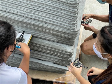
 The 3D printed rock allows the students to visualize the rock in 3D, plus it is available on campus. On the right, student measuring real 2D rock in the field in Bali. Photo credit from left: Lee Wei Kit, Benoit Taisne (the two middle photos), and Gareth.
Use of 3D printed rocks for geoscience teaching
An unexpected collaboration between ASE and the Singapore Centre for 3D Printing (SC3DP) arose in the absence of the field trip to Bali. Assoc Prof Benoit Taisne would normally take the first year students to a field site in Bali, where they learn a concept in geology called ‘Strike and Dip’. Students measure the indentation between blocks using their compass as well as any tricks that they may find to extend the surface, and then use their measurements to record the Strike and Dip of the rock structure.
This concept cannot be taught indoors, as the compass used for the measurement due to proximity of metal affecting the measurement (a consequence of compasses’ sensitivity to magnetic fields). Though equivalent rocks can be found at other locations in Singapore, 3D printing of rocks provide a unique solution with double advantages; firsts, the students have access to the rock on campus, and second, the students can the walk around the rock and visualise the structure in 3D, which is never the case at a field site, where rocks for obvious reasons can only be viewed in 2D. So it is both more convenient and a better learning experience.
For advanced field courses, ASE students are taken out to do the measurement on real rocks in Singapore, with more fine details to measure than the 3D printed rock can achieve, but for first year geology, the 3D printed rock is ideal.
Read more about the 3D printed rock here
We would like to thank Asst Prof Judith Hubbard and Brian Perttu for contributing to the text on ES3002, Dr Sylvan Rigaud for contributing to the text on ES2101, Lee Wei Kit for contributing to the text on ES1006, And Assoc Prof Benoit Taisne and Lee Wei Kit for contributing to the text on 3D printed rock.
.tmb-listing.jpg?Culture=en&sfvrsn=f3ea25b7_1)